Orange City night lights from space
Night Light of Orange City (Florida) from space (United States) Src. Average luminocity for 10x10km area is 59.8512% and for 50x50km: 23.885%.
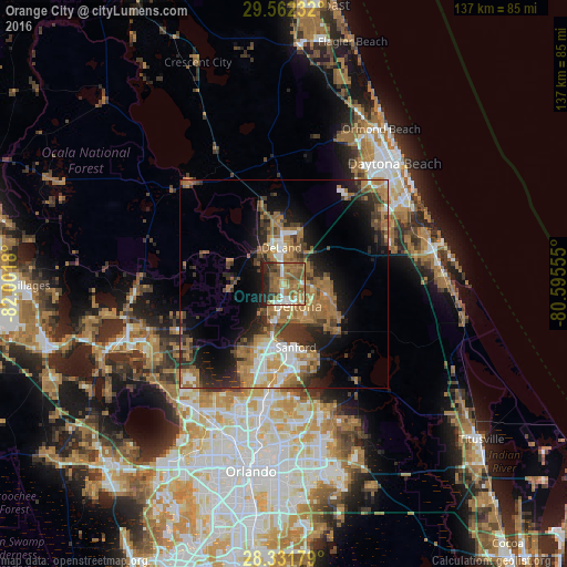
Analysis of Orange City night lights 2016
Square area 10x10 km:
 6.75%
6.75%90-99
8.33%80-89
4.17%70-79
5.36%60-69
27.58%50-59
20.24%40-49
7.34%30-39
4.76%20-29
13.89%10-19
1.59%0-9
0%Square area 50x50 km:
2.49%90-99
3.2%80-89
1.3%70-79
2.69%60-69
9.71%50-59
3.94%40-49
3.12%30-39
4.79%20-29
5.89%10-19
9.84%0-9
53.01%Clear (daylight) street map image can be seen on geolist.org.
Map coordinates:
29° 33' 44.4" North, 82° 0' 6.5" West
28° 56' 56" North, 81° 17' 55.2" West
28° 19' 54.4" North, 80° 35' 44" West
Some cities around Orange City sort by population:
• Deltona
6.4 km =4 mi,  147°
147°
• Sanford
16.7 km =10.4 mi,  171°
171°
• DeLand
8.8 km =5.5 mi,  357°
357°
• DeBary
7.4 km =4.6 mi,  187°
187°
• Lake Mary
21.2 km =13.2 mi, 185°
• Longwood
27.6 km =17.1 mi, 188°
• Heathrow
21.8 km =13.5 mi,  199°
199°
• Samsula-Spruce Creek
25.6 km =15.9 mi,  64°
64°
4167055 (p: 11,210)
Sources (retrieved 2019-11-25):
» Earth at Night: Flat Maps 2012, 2016