Oradell night lights from space
Night Light of Oradell (New Jersey) from space (United States) Src. Average luminocity for 10x10km area is 82.4898% and for 50x50km: 74.5466%.
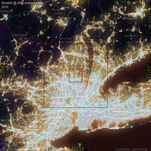
Analysis of Oradell night lights 2016
Square area 10x10 km:
 16.67%
90-99
20.24%80-89
19.22%70-79
22.28%60-69
15.65%50-59
5.95%40-49
0%30-39
0%20-29
0%10-19
0%0-9
0%Square area 50x50 km:
26.88%90-99
16.85%80-89
8.07%70-79
10.92%60-69
12.66%50-59
6.87%40-49
3.93%30-39
3.45%20-29
4.2%10-19
2.35%0-9
3.83%Clear (daylight) street map image can be seen on geolist.org.
Map coordinates:
41° 29' 15.2" North, 74° 44' 23.8" West
40° 57' 31.4" North, 74° 2' 12.5" West
40° 25' 32.1" North, 73° 20' 1.3" West
Some cities around Oradell sort by population:
• Bergenfield
4.8 km =3 mi,  136°
136°
• Paramus
3.6 km =2.2 mi,  244°
244°
• Dumont
3.9 km =2.4 mi,  120°
120°
• New Milford
3 km =1.9 mi,  150°
150°
• River Edge
3.3 km =2.1 mi,  184°
184°
• Westwood
3.6 km =2.2 mi,  5°
5°
• River Vale
4.6 km =2.9 mi,  26°
26°
• Emerson
2.1 km =1.3 mi,  24°
24°
5102208 (p: 8,218)
Sources (retrieved 2019-11-25):
» Earth at Night: Flat Maps 2012, 2016