Emerson night lights from space
Night Light of Emerson (New Jersey) from space (United States) Src. Average luminocity for 10x10km area is 75.6888% and for 50x50km: 72.0381%.
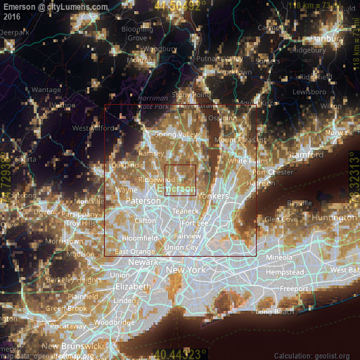
Analysis of Emerson night lights 2016
Square area 10x10 km:
 9.69%
9.69%90-99
12.93%80-89
13.44%70-79
21.77%60-69
29.59%50-59
12.59%40-49
0%30-39
0%20-29
0%10-19
0%0-9
0%Square area 50x50 km:
24.52%90-99
16.44%80-89
8.02%70-79
10.56%60-69
12.62%50-59
6.92%40-49
4.06%30-39
3.89%20-29
5.13%10-19
2.98%0-9
4.86%Clear (daylight) street map image can be seen on geolist.org.
Map coordinates:
41° 30' 17.7" North, 74° 43' 45.8" West
40° 58' 34.4" North, 74° 1' 34.5" West
40° 26' 35.6" North, 73° 19' 23.3" West
Some cities around Emerson sort by population:
• Dumont
4.7 km =2.9 mi,  147°
147°
• New Milford
4.6 km =2.9 mi,  172°
172°
• Westwood
1.8 km =1.1 mi,  342°
342°
• Hillsdale
3.2 km =2 mi, 337°
• River Vale
2.4 km =1.5 mi,  29°
29°
• Closter
5.4 km =3.4 mi,  93°
93°
• Oradell
2.1 km =1.3 mi,  204°
204°
• Old Tappan
4.8 km =3 mi,  37°
37°
5097649 (p: 7,697)
Sources (retrieved 2019-11-25):
» Earth at Night: Flat Maps 2012, 2016