Oak Grove night lights from space
Night Light of Oak Grove (Kentucky) from space (United States) Src. Average luminocity for 10x10km area is 2.7808% and for 50x50km: 2.3971%.
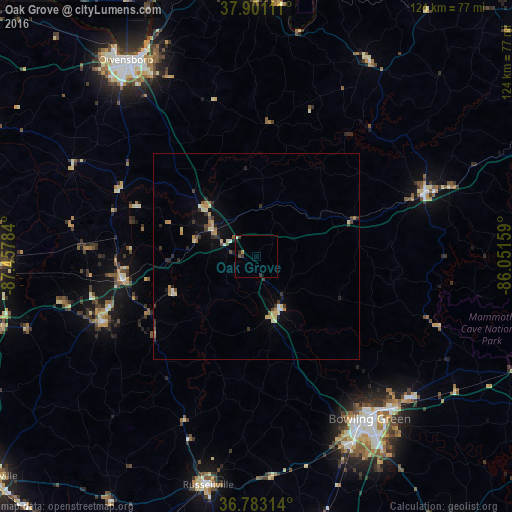
Analysis of Oak Grove night lights 2016
Square area 10x10 km:
 0.49%
0.49%90-99
0.16%80-89
0%70-79
0.32%60-69
0.32%50-59
0.49%40-49
0.16%30-39
1.95%20-29
1.3%10-19
0%0-9
94.81%Square area 50x50 km:
0.14%90-99
0.2%80-89
0.48%70-79
0.35%60-69
0.31%50-59
0.21%40-49
0.24%30-39
0.66%20-29
0.48%10-19
0.71%0-9
96.23%Clear (daylight) street map image can be seen on geolist.org.
Map coordinates:
37° 54' 4" North, 87° 27' 28.2" West
37° 20' 39.2" North, 86° 45' 17" West
36° 46' 59.3" North, 86° 3' 5.7" West
Some cities around Oak Grove sort by population:
• Bowling Green
48 km =29.8 mi,  144°
144°
• Owensboro
57.3 km =35.6 mi,  326°
326°
• Madisonville
65.8 km =40.9 mi,  268°
268°
• Morehead
38.2 km =23.7 mi,  257°
257°
• Russellville
56.7 km =35.2 mi,  191°
191°
• Leitchfield
43.4 km =27 mi,  69°
69°
• Knottsville
49.3 km =30.6 mi,  344°
344°
• Central City
33.1 km =20.6 mi, 260°
4302828 (p: 7,989)
Sources (retrieved 2019-11-25):
» Earth at Night: Flat Maps 2012, 2016