Morehead night lights from space
Night Light of Morehead (Kentucky) from space (United States) Src. Average luminocity for 10x10km area is 25.665% and for 50x50km: 5.6501%.
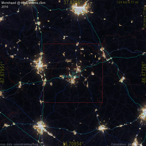
Analysis of Morehead night lights 2016
Square area 10x10 km:
 1.53%
1.53%90-99
2.89%80-89
2.38%70-79
2.72%60-69
2.38%50-59
6.12%40-49
4.59%30-39
6.8%20-29
4.59%10-19
42.69%0-9
23.3%Square area 50x50 km:
0.15%90-99
0.41%80-89
0.74%70-79
0.8%60-69
0.84%50-59
0.67%40-49
0.9%30-39
1.68%20-29
1.4%10-19
4.7%0-9
87.7%Clear (daylight) street map image can be seen on geolist.org.
Map coordinates:
37° 49' 43" North, 87° 52' 46.2" West
37° 16' 16.1" North, 87° 10' 35" West
36° 42' 34.3" North, 86° 28' 23.7" West
Some cities around Morehead sort by population:
• Owensboro
56.2 km =34.9 mi,  5°
5°
• Hopkinsville
53 km =32.9 mi,  211°
211°
• Madisonville
29.2 km =18.1 mi,  282°
282°
• Oak Grove
38.2 km =23.7 mi,  77°
77°
• Russellville
53.9 km =33.5 mi,  151°
151°
• Knottsville
60.6 km =37.7 mi,  23°
23°
• Princeton
65 km =40.4 mi,  253°
253°
• Central City
5.3 km =3.3 mi,  61°
61°
4301317 (p: 7,622)
Sources (retrieved 2019-11-25):
» Earth at Night: Flat Maps 2012, 2016