Conover night lights from space
Night Light of Conover (North Carolina) from space (United States) Src. Average luminocity for 10x10km area is 71.6049% and for 50x50km: 25.0404%.
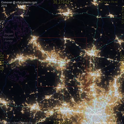
Analysis of Conover night lights 2016
Square area 10x10 km:
 12.24%
90-99
13.29%80-89
20.45%70-79
8.92%60-69
13.99%50-59
9.44%40-49
10.84%30-39
7.52%20-29
3.32%10-19
0%0-9
0%Square area 50x50 km:
1.81%90-99
2.2%80-89
4.08%70-79
3.5%60-69
4.73%50-59
3.87%40-49
4.62%30-39
6.59%20-29
9.58%10-19
14.4%0-9
44.62%Clear (daylight) street map image can be seen on geolist.org.
Map coordinates:
36° 16' 31.5" North, 81° 55' 18.6" West
35° 42' 23.5" North, 81° 13' 7.3" West
35° 8' 0.7" North, 80° 30' 56.1" West
Some cities around Conover sort by population:
• Hickory
11.4 km =7.1 mi,  285°
285°
• Statesville
31.1 km =19.3 mi,  74°
74°
• Lenoir
37 km =23 mi,  308°
308°
• Newton
4.1 km =2.5 mi,  183°
183°
• Lincolnton
26.1 km =16.2 mi,  187°
187°
• Saint Stephens
8.1 km =5 mi,  322°
322°
• Sawmills
26.6 km =16.5 mi,  299°
299°
• Lake Norman of Catawba
26.9 km =16.7 mi,  119°
119°
4461696 (p: 8,248)
Sources (retrieved 2019-11-25):
» Earth at Night: Flat Maps 2012, 2016