Sawmills night lights from space
Night Light of Sawmills (North Carolina) from space (United States) Src. Average luminocity for 10x10km area is 46.8899% and for 50x50km: 22.4114%.
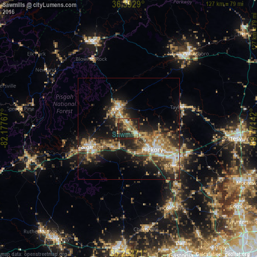
Analysis of Sawmills night lights 2016
Square area 10x10 km:
 2.1%
2.1%90-99
4.9%80-89
8.04%70-79
9.09%60-69
11.19%50-59
5.94%40-49
10.14%30-39
9.62%20-29
24.83%10-19
14.16%0-9
0%Square area 50x50 km:
2.02%90-99
2.53%80-89
3.61%70-79
3.54%60-69
3.98%50-59
3.85%40-49
3.91%30-39
4.63%20-29
7.29%10-19
12.2%0-9
52.45%Clear (daylight) street map image can be seen on geolist.org.
Map coordinates:
36° 23' 34.4" North, 82° 10' 39.6" West
35° 49' 29.5" North, 81° 28' 28.3" West
35° 15' 9.8" North, 80° 46' 17.1" West
Some cities around Sawmills sort by population:
• Hickory
15.8 km =9.8 mi,  130°
130°
• Boone
47.1 km =29.3 mi,  337°
337°
• Lenoir
11.5 km =7.1 mi,  329°
329°
• Morganton
20.9 km =13 mi,  245°
245°
• Newton
28.6 km =17.8 mi, 127°
• Lincolnton
43.8 km =27.2 mi,  153°
153°
• Saint Stephens
19.4 km =12.1 mi,  110°
110°
• Conover
26.6 km =16.5 mi,  119°
119°
4490510 (p: 5,104)
Sources (retrieved 2019-11-25):
» Earth at Night: Flat Maps 2012, 2016