Princeton night lights from space
Night Light of Princeton (Kentucky) from space (United States) Src. Average luminocity for 10x10km area is 22.0442% and for 50x50km: 2.6071%.
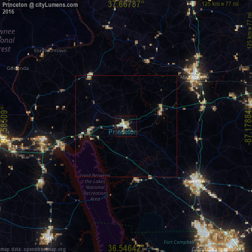
Analysis of Princeton night lights 2016
Square area 10x10 km:
 1.53%
1.53%90-99
4.76%80-89
3.91%70-79
1.02%60-69
2.89%50-59
3.57%40-49
2.04%30-39
5.78%20-29
1.02%10-19
17.18%0-9
56.29%Square area 50x50 km:
0.11%90-99
0.35%80-89
0.4%70-79
0.17%60-69
0.35%50-59
0.38%40-49
0.34%30-39
0.8%20-29
0.44%10-19
1.03%0-9
95.63%Clear (daylight) street map image can be seen on geolist.org.
Map coordinates:
37° 40' 4.3" North, 88° 35' 6.3" West
37° 6' 33.2" North, 87° 52' 55.1" West
36° 32' 47.1" North, 87° 10' 43.8" West
Some cities around Princeton sort by population:
• Hopkinsville
44 km =27.3 mi,  127°
127°
• Paducah
63.8 km =39.6 mi,  267°
267°
• Madisonville
41.7 km =25.9 mi,  54°
54°
• Murray
67.5 km =41.9 mi,  214°
214°
• Fort Campbell North
63 km =39.1 mi,  143°
143°
• Morehead
65 km =40.4 mi,  73°
73°
• Oak Grove
63 km =39.1 mi, 141°
• Central City
70.3 km =43.7 mi, 73°
4305266 (p: 6,174)
Sources (retrieved 2019-11-25):
» Earth at Night: Flat Maps 2012, 2016