Monticello night lights from space
Night Light of Monticello (New York) from space (United States) Src. Average luminocity for 10x10km area is 21.8636% and for 50x50km: 4.2957%.
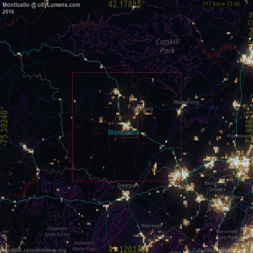
Analysis of Monticello night lights 2016
Square area 10x10 km:
 1.3%
1.3%90-99
1.62%80-89
3.9%70-79
2.6%60-69
5.19%50-59
2.92%40-49
3.25%30-39
3.41%20-29
1.79%10-19
22.73%0-9
51.3%Square area 50x50 km:
0.32%90-99
0.32%80-89
0.61%70-79
0.46%60-69
0.75%50-59
0.59%40-49
0.78%30-39
0.93%20-29
1%10-19
2.32%0-9
91.91%Clear (daylight) street map image can be seen on geolist.org.
Map coordinates:
42° 10' 43.9" North, 75° 23' 32.9" West
41° 39' 20.3" North, 74° 41' 21.6" West
41° 7' 41.4" North, 73° 59' 10.4" West
Some cities around Monticello sort by population:
• Middletown
32.2 km =20 mi,  136°
136°
• Wawarsing
29.9 km =18.6 mi,  67°
67°
• Fallsburg
11.2 km =7 mi,  40°
40°
• Scotchtown
33.5 km =20.8 mi,  125°
125°
• Port Jervis
31.2 km =19.4 mi,  180°
180°
• Mechanicstown
34.4 km =21.4 mi, 133°
• Walden
42.9 km =26.7 mi,  104°
104°
• Goshen
41.5 km =25.8 mi, 132°
5127359 (p: 6,505)
Sources (retrieved 2019-11-25):
» Earth at Night: Flat Maps 2012, 2016