Port Jervis night lights from space
Night Light of Port Jervis (New York) from space (United States) Src. Average luminocity for 10x10km area is 16.8112% and for 50x50km: 4.2542%.
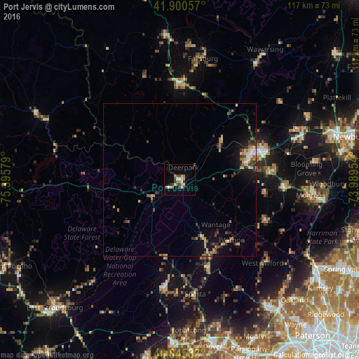
Analysis of Port Jervis night lights 2016
Square area 10x10 km:
 1.53%
1.53%90-99
2.72%80-89
2.04%70-79
1.87%60-69
3.06%50-59
2.38%40-49
2.72%30-39
2.04%20-29
1.53%10-19
5.1%0-9
75%Square area 50x50 km:
0.26%90-99
0.36%80-89
0.74%70-79
0.6%60-69
0.58%50-59
0.49%40-49
0.67%30-39
0.9%20-29
1.02%10-19
2.9%0-9
91.48%Clear (daylight) street map image can be seen on geolist.org.
Map coordinates:
41° 54' 2.1" North, 75° 23' 44.8" West
41° 22' 30.3" North, 74° 41' 33.6" West
40° 50' 43.2" North, 73° 59' 22.3" West
Some cities around Port Jervis sort by population:
• Middletown
23.8 km =14.8 mi,  70°
70°
• Sparta
38.3 km =23.8 mi,  173°
173°
• Scotchtown
30.1 km =18.7 mi, 66°
• Newton
35.6 km =22.1 mi,  188°
188°
• Mechanicstown
26.5 km =16.5 mi, 73°
• Warwick
30.8 km =19.1 mi,  115°
115°
• Monticello
31.2 km =19.4 mi,  0°
0°
• Goshen
30.9 km =19.2 mi,  84°
84°
5132016 (p: 8,609)
Sources (retrieved 2019-11-25):
» Earth at Night: Flat Maps 2012, 2016