Wawarsing night lights from space
Night Light of Wawarsing (New York) from space (United States) Src. Average luminocity for 10x10km area is 8.1786% and for 50x50km: 3.4615%.
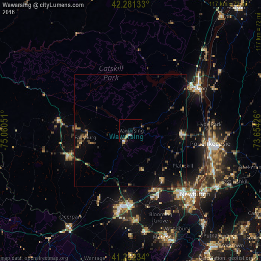
Analysis of Wawarsing night lights 2016
Square area 10x10 km:
 1.62%
1.62%90-99
0.97%80-89
1.62%70-79
0%60-69
1.62%50-59
0.97%40-49
0%30-39
0.49%20-29
3.08%10-19
1.3%0-9
88.31%Square area 50x50 km:
0.17%90-99
0.14%80-89
0.45%70-79
0.33%60-69
0.57%50-59
0.44%40-49
0.72%30-39
0.77%20-29
1.17%10-19
2.39%0-9
92.86%Clear (daylight) street map image can be seen on geolist.org.
Map coordinates:
42° 16' 52.8" North, 75° 3' 37.8" West
41° 45' 32.3" North, 74° 21' 26.6" West
41° 13' 56.4" North, 73° 39' 15.3" West
Some cities around Wawarsing sort by population:
• Fallsburg
20.5 km =12.7 mi,  261°
261°
• Scotchtown
30.9 km =19.2 mi,  180°
180°
• New Paltz
22.5 km =14 mi,  93°
93°
• Orange Lake
32.5 km =20.2 mi,  138°
138°
• Walden
26.1 km =16.2 mi,  147°
147°
• Monticello
29.9 km =18.6 mi,  247°
247°
• Highland
33.2 km =20.6 mi,  97°
97°
• Marbletown
24.5 km =15.2 mi,  55°
55°
5143443 (p: 12,925)
Sources (retrieved 2019-11-25):
» Earth at Night: Flat Maps 2012, 2016