Goshen night lights from space
Night Light of Goshen (New York) from space (United States) Src. Average luminocity for 10x10km area is 26.8844% and for 50x50km: 13.6571%.
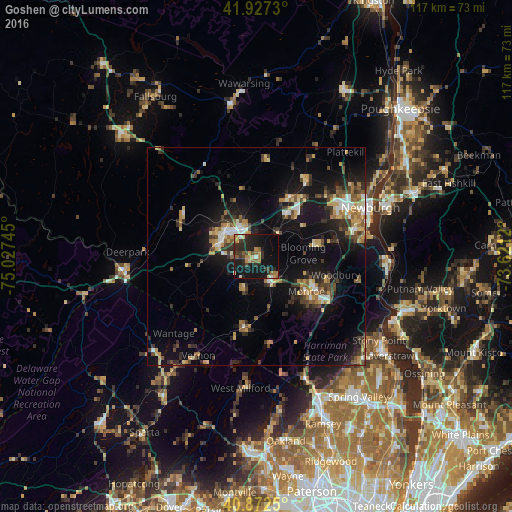
Analysis of Goshen night lights 2016
Square area 10x10 km:
 0.85%
0.85%90-99
1.36%80-89
2.89%70-79
5.27%60-69
4.76%50-59
3.4%40-49
3.57%30-39
6.12%20-29
14.97%10-19
37.59%0-9
19.22%Square area 50x50 km:
1.17%90-99
1.32%80-89
1.75%70-79
2%60-69
1.86%50-59
1.84%40-49
2.11%30-39
2.6%20-29
3.77%10-19
12.85%0-9
68.73%Clear (daylight) street map image can be seen on geolist.org.
Map coordinates:
41° 55' 38.3" North, 75° 1' 38.8" West
41° 24' 7.3" North, 74° 19' 27.6" West
40° 52' 21" North, 73° 37' 16.3" West
Some cities around Goshen sort by population:
• Middletown
9.6 km =6 mi,  300°
300°
• Kiryas Joel
14.7 km =9.1 mi,  117°
117°
• Woodbury
18.7 km =11.6 mi,  102°
102°
• Scotchtown
9.3 km =5.8 mi,  341°
341°
• Monroe
14 km =8.7 mi, 124°
• Mechanicstown
7 km =4.3 mi,  310°
310°
• Warwick
16.5 km =10.3 mi,  190°
190°
• Washingtonville
13.5 km =8.4 mi,  77°
77°
5118920 (p: 5,397)
Sources (retrieved 2019-11-25):
» Earth at Night: Flat Maps 2012, 2016