Monessen night lights from space
Night Light of Monessen (Pennsylvania) from space (United States) Src. Average luminocity for 10x10km area is 52.3068% and for 50x50km: 29.0381%.
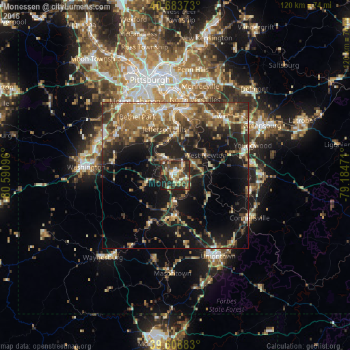
Analysis of Monessen night lights 2016
Square area 10x10 km:
 4.55%
4.55%90-99
8.93%80-89
6.98%70-79
7.79%60-69
7.63%50-59
11.2%40-49
13.96%30-39
13.96%20-29
19.64%10-19
5.36%0-9
0%Square area 50x50 km:
2.05%90-99
3.65%80-89
3.31%70-79
4.04%60-69
5.95%50-59
6.23%40-49
5.88%30-39
5.98%20-29
9.25%10-19
16.61%0-9
37.05%Clear (daylight) street map image can be seen on geolist.org.
Map coordinates:
40° 41' 1.4" North, 80° 35' 27.5" West
40° 8' 54.3" North, 79° 53' 16.2" West
39° 36' 31.8" North, 79° 11' 5" West
Some cities around Monessen sort by population:
• South Park Township
19 km =11.8 mi,  331°
331°
• Jefferson Hills
16.3 km =10.1 mi,  346°
346°
• Pleasant Hills
21.7 km =13.5 mi,  343°
343°
• White Oak
22.1 km =13.7 mi,  17°
17°
• Maple Glen
16.6 km =10.3 mi,  207°
207°
• Wilson
18 km =11.2 mi,  359°
359°
• Clairton
16 km =9.9 mi,  1°
1°
• California
9.2 km =5.7 mi,  182°
182°
5201665 (p: 7,483)
Sources (retrieved 2019-11-25):
» Earth at Night: Flat Maps 2012, 2016