Jefferson Hills night lights from space
Night Light of Jefferson Hills (Pennsylvania) from space (United States) Src. Average luminocity for 10x10km area is 60.6037% and for 50x50km: 47.3791%.
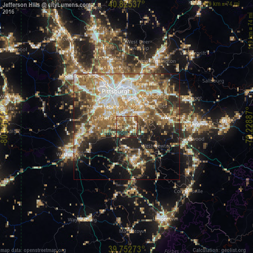
Analysis of Jefferson Hills night lights 2016
Square area 10x10 km:
 5.1%
5.1%90-99
9.69%80-89
8.84%70-79
8.67%60-69
18.71%50-59
17.69%40-49
11.9%30-39
6.46%20-29
12.93%10-19
0%0-9
0%Square area 50x50 km:
7.72%90-99
8.75%80-89
5.77%70-79
6.98%60-69
9.94%50-59
9.04%40-49
6.87%30-39
6.53%20-29
9.05%10-19
11.67%0-9
17.68%Clear (daylight) street map image can be seen on geolist.org.
Map coordinates:
40° 49' 31.3" North, 80° 38' 6.4" West
40° 17' 28.2" North, 79° 55' 55.2" West
39° 45' 9.8" North, 79° 13' 43.9" West
Some cities around Jefferson Hills sort by population:
• Baldwin
6.6 km =4.1 mi,  322°
322°
• McKeesport
8.5 km =5.3 mi,  42°
42°
• Whitehall
9.2 km =5.7 mi,  327°
327°
• South Park Township
5.3 km =3.3 mi,  278°
278°
• Brentwood
9.5 km =5.9 mi,  337°
337°
• Pleasant Hills
5.5 km =3.4 mi, 333°
• Wilson
4 km =2.5 mi,  58°
58°
• Clairton
4.3 km =2.7 mi,  88°
88°
5195297 (p: 11,360)
Sources (retrieved 2019-11-25):
» Earth at Night: Flat Maps 2012, 2016