Pleasant Hills night lights from space
Night Light of Pleasant Hills (Pennsylvania) from space (United States) Src. Average luminocity for 10x10km area is 76.4864% and for 50x50km: 52.8788%.
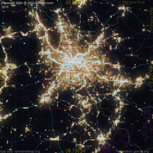
Analysis of Pleasant Hills night lights 2016
Square area 10x10 km:
 11.73%
90-99
15.99%80-89
11.22%70-79
18.88%60-69
28.57%50-59
11.22%40-49
2.21%30-39
0.17%20-29
0%10-19
0%0-9
0%Square area 50x50 km:
8.59%90-99
9.67%80-89
6.58%70-79
7.73%60-69
10.94%50-59
11.55%40-49
8.25%30-39
6.9%20-29
9.14%10-19
11.06%0-9
9.6%Clear (daylight) street map image can be seen on geolist.org.
Map coordinates:
40° 52' 10.1" North, 80° 39' 49.5" West
40° 20' 8.3" North, 79° 57' 38.2" West
39° 47' 51.1" North, 79° 15' 27" West
Some cities around Pleasant Hills sort by population:
• Bethel Park
6.7 km =4.2 mi,  262°
262°
• Baldwin
1.6 km =1 mi,  280°
280°
• Whitehall
3.8 km =2.4 mi,  317°
317°
• South Park Township
5 km =3.1 mi,  214°
214°
• Jefferson Hills
5.5 km =3.4 mi,  153°
153°
• Brentwood
4.1 km =2.5 mi,  342°
342°
• Castle Shannon
6.1 km =3.8 mi,  301°
301°
• Wilson
6.5 km =4 mi,  115°
115°
5206510 (p: 8,252)
Sources (retrieved 2019-11-25):
» Earth at Night: Flat Maps 2012, 2016