Mokena night lights from space
Night Light of Mokena (Illinois) from space (United States) Src. Average luminocity for 10x10km area is 78.1071% and for 50x50km: 61.0799%.

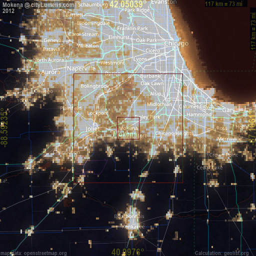
Analysis of Mokena night lights 2016
Square area 10x10 km:
 13.1%
13.1%90-99
14.29%80-89
19.9%70-79
17.69%60-69
19.9%50-59
14.12%40-49
1.02%30-39
0%20-29
0%10-19
0%0-9
0%Square area 50x50 km:
17.74%90-99
13.81%80-89
9.82%70-79
10.1%60-69
9.77%50-59
6.7%40-49
2.68%30-39
2.15%20-29
3.65%10-19
5.77%0-9
17.83%Clear (daylight) street map image can be seen on geolist.org.
Map coordinates:
42° 3' 1.4" North, 88° 35' 32.5" West
41° 31' 34.1" North, 87° 53' 21.2" West
40° 59' 51.4" North, 87° 11' 10" West
Some cities around Mokena sort by population:
• Orland Park
11.9 km =7.4 mi,  14°
14°
• Tinley Park
10.2 km =6.3 mi,  58°
58°
• New Lenox
6.6 km =4.1 mi,  256°
256°
• Homer Glen
9.2 km =5.7 mi,  333°
333°
• Frankfort
4.8 km =3 mi,  134°
134°
• Goodings Grove
12 km =7.5 mi,  343°
343°
• Frankfort Square
7.2 km =4.5 mi,  96°
96°
• Orland Hills
7.6 km =4.7 mi,  30°
30°
4902475 (p: 19,923)
Sources (retrieved 2019-11-25):
» Earth at Night: Flat Maps 2012, 2016