Goodings Grove night lights from space
Night Light of Goodings Grove (Illinois) from space (United States) Src. Average luminocity for 10x10km area is 65.9448% and for 50x50km: 80.2269%.
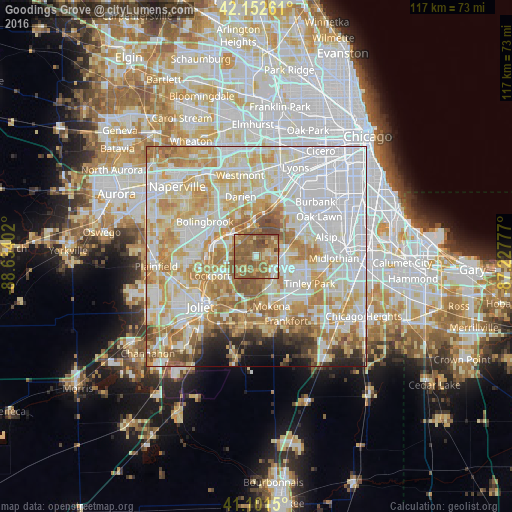
Analysis of Goodings Grove night lights 2016
Square area 10x10 km:
 4.06%
4.06%90-99
5.36%80-89
10.88%70-79
10.88%60-69
25.81%50-59
37.82%40-49
4.87%30-39
0.32%20-29
0%10-19
0%0-9
0%Square area 50x50 km:
28.16%90-99
19.4%80-89
13.18%70-79
12.24%60-69
10.49%50-59
6.58%40-49
2.36%30-39
1.61%20-29
2.42%10-19
2.4%0-9
1.15%Clear (daylight) street map image can be seen on geolist.org.
Map coordinates:
42° 9' 9.4" North, 88° 38' 2.5" West
41° 37' 45.1" North, 87° 55' 51.2" West
41° 6' 5.4" North, 87° 13' 40" West
Some cities around Goodings Grove sort by population:
• Orland Park
6.4 km =4 mi,  88°
88°
• Lockport
11.4 km =7.1 mi,  247°
247°
• Homer Glen
3.3 km =2.1 mi,  190°
190°
• Mokena
12 km =7.5 mi,  163°
163°
• Palos Hills
12.1 km =7.5 mi,  51°
51°
• Lemont
7.7 km =4.8 mi,  310°
310°
• Palos Heights
12 km =7.5 mi,  68°
68°
• Orland Hills
8.8 km =5.5 mi,  123°
123°
4894061 (p: 18,569)
Sources (retrieved 2019-11-25):
» Earth at Night: Flat Maps 2012, 2016