El Dorado night lights from space
Night Light of El Dorado (Arkansas) from space (United States) Src. Average luminocity for 10x10km area is 53.5769% and for 50x50km: 5.0631%.
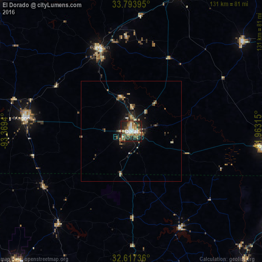
Analysis of El Dorado night lights 2016
Square area 10x10 km:
 9.09%
9.09%90-99
8.39%80-89
8.22%70-79
5.94%60-69
11.01%50-59
10.49%40-49
4.02%30-39
9.62%20-29
21.15%10-19
12.06%0-9
0%Square area 50x50 km:
0.44%90-99
0.66%80-89
0.69%70-79
0.44%60-69
0.88%50-59
0.85%40-49
0.58%30-39
0.97%20-29
1.79%10-19
3.39%0-9
89.3%Clear (daylight) street map image can be seen on geolist.org.
Map coordinates:
33° 47' 38.2" North, 93° 22' 9.8" West
33° 12' 27.5" North, 92° 39' 58.6" West
32° 37' 2.5" North, 91° 57' 47.3" West
Some cities around El Dorado sort by population:
• Ruston
76.1 km =47.3 mi,  178°
178°
• Magnolia
53.7 km =33.4 mi,  277°
277°
• Camden
44.7 km =27.8 mi,  339°
339°
• Bastrop
85.1 km =52.9 mi,  124°
124°
• Warren
71.7 km =44.6 mi,  51°
51°
• Crossett
66.2 km =41.1 mi,  97°
97°
• Grambling
75.7 km =47 mi, 183°
• Springhill
77.9 km =48.4 mi,  253°
253°
4109785 (p: 18,386)
Sources (retrieved 2019-11-25):
» Earth at Night: Flat Maps 2012, 2016