Midway night lights from space
Night Light of Midway (Florida) from space (United States) Src. Average luminocity for 10x10km area is 27.8846% and for 50x50km: 19.7289%.
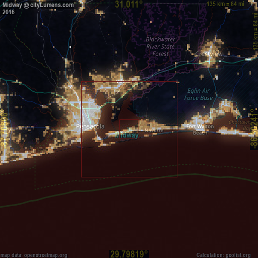
Analysis of Midway night lights 2016
Square area 10x10 km:
 0.55%
0.55%90-99
2.01%80-89
9.52%70-79
4.95%60-69
3.3%50-59
0.55%40-49
3.11%30-39
3.85%20-29
2.75%10-19
49.27%0-9
20.15%Square area 50x50 km:
3.35%90-99
2.85%80-89
3.31%70-79
2.96%60-69
3.63%50-59
1.11%40-49
2.16%30-39
3%20-29
5.41%10-19
11.78%0-9
60.45%Clear (daylight) street map image can be seen on geolist.org.
Map coordinates:
31° 0' 39.6" North, 87° 42' 31.2" West
30° 24' 23.3" North, 87° 0' 19.9" West
29° 47' 53.5" North, 86° 18' 8.7" West
Some cities around Midway sort by population:
• East Pensacola Heights
16.9 km =10.5 mi,  278°
278°
• Pensacola
20.3 km =12.6 mi,  274°
274°
• Navarre
13.6 km =8.5 mi,  92°
92°
• Ferry Pass
22.9 km =14.2 mi,  300°
300°
• Brent
23.2 km =14.4 mi,  287°
287°
• East Milton
23.3 km =14.5 mi,  356°
356°
• Milton
25.3 km =15.7 mi,  352°
352°
• Gulf Breeze
16.1 km =10 mi,  250°
250°
7315234 (p: 16,115)
Sources (retrieved 2019-11-25):
» Earth at Night: Flat Maps 2012, 2016