Middlesboro night lights from space
Night Light of Middlesboro (Kentucky) from space (United States) Src. Average luminocity for 10x10km area is 31.9231% and for 50x50km: 4.4346%.
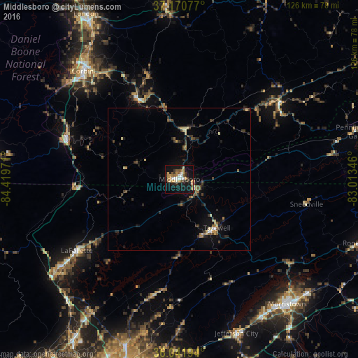
Analysis of Middlesboro night lights 2016
Square area 10x10 km:
 3.85%
3.85%90-99
3.48%80-89
2.75%70-79
9.34%60-69
3.3%50-59
5.13%40-49
1.47%30-39
5.13%20-29
5.31%10-19
43.04%0-9
17.22%Square area 50x50 km:
0.24%90-99
0.25%80-89
0.68%70-79
0.61%60-69
0.45%50-59
0.68%40-49
0.64%30-39
1.18%20-29
1.13%10-19
3.45%0-9
90.7%Clear (daylight) street map image can be seen on geolist.org.
Map coordinates:
37° 10' 14.8" North, 84° 25' 11" West
36° 36' 30.3" North, 83° 42' 59.7" West
36° 2' 31" North, 83° 0' 48.5" West
Some cities around Middlesboro sort by population:
• Knoxville
74.3 km =46.2 mi,  194°
194°
• Morristown
57.9 km =36 mi,  139°
139°
• Clinton
67.3 km =41.8 mi,  213°
213°
• Jefferson City
57.7 km =35.9 mi,  159°
159°
• London
66.4 km =41.3 mi,  330°
330°
• LaFollette
43.9 km =27.3 mi,  235°
235°
• Corbin
50.8 km =31.6 mi,  318°
318°
• Williamsburg
42.3 km =26.3 mi,  290°
290°
4300717 (p: 10,730)
Sources (retrieved 2019-11-25):
» Earth at Night: Flat Maps 2012, 2016