LaFollette night lights from space
Night Light of LaFollette (Tennessee) from space (United States) Src. Average luminocity for 10x10km area is 32.1591% and for 50x50km: 6.2207%.
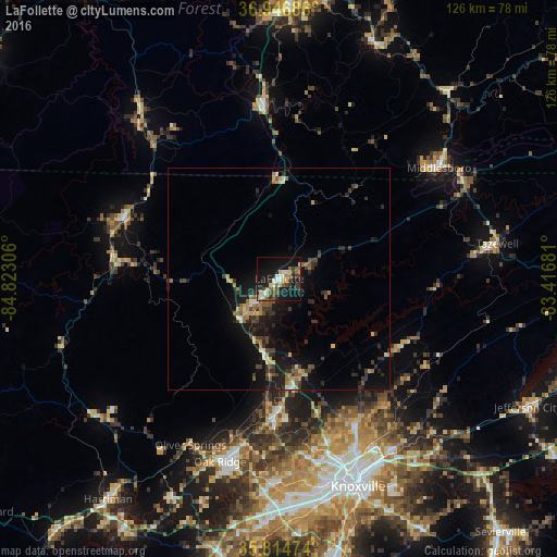
Analysis of LaFollette night lights 2016
Square area 10x10 km:
 4.37%
4.37%90-99
3.85%80-89
5.24%70-79
1.92%60-69
3.67%50-59
6.29%40-49
5.07%30-39
7.69%20-29
4.9%10-19
36.71%0-9
20.28%Square area 50x50 km:
0.32%90-99
0.43%80-89
0.84%70-79
0.67%60-69
0.93%50-59
1.01%40-49
0.93%30-39
1.82%20-29
1.62%10-19
6.93%0-9
84.49%Clear (daylight) street map image can be seen on geolist.org.
Map coordinates:
36° 56' 48.7" North, 84° 49' 23" West
36° 22' 58.3" North, 84° 7' 11.7" West
35° 48' 53.1" North, 83° 25' 0.5" West
Some cities around LaFollette sort by population:
• Knoxville
50.2 km =31.2 mi,  159°
159°
• Oak Ridge
43.5 km =27 mi,  197°
197°
• Farragut
55.5 km =34.5 mi,  183°
183°
• Middlesboro
43.9 km =27.3 mi,  55°
55°
• Clinton
31.1 km =19.3 mi, 181°
• Corbin
62.9 km =39.1 mi,  1°
1°
• Harriman
63.2 km =39.3 mi,  217°
217°
• Williamsburg
40.2 km =25 mi,  354°
354°
4635037 (p: 7,456)
Sources (retrieved 2019-11-25):
» Earth at Night: Flat Maps 2012, 2016