Kingston night lights from space
Night Light of Kingston (New Hampshire) from space (United States) Src. Average luminocity for 10x10km area is 6.5937% and for 50x50km: 19.5469%.
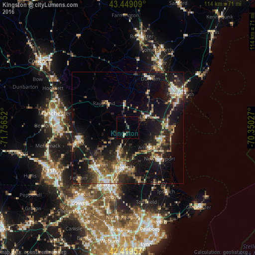
Analysis of Kingston night lights 2016
Square area 10x10 km:
 0%
0%90-99
1.11%80-89
1.43%70-79
0%60-69
0.32%50-59
0.95%40-49
0.48%30-39
1.75%20-29
1.9%10-19
0.16%0-9
91.9%Square area 50x50 km:
1.88%90-99
2.58%80-89
2.18%70-79
2.2%60-69
2.81%50-59
3.53%40-49
3.06%30-39
3.47%20-29
7.17%10-19
16.99%0-9
54.12%Clear (daylight) street map image can be seen on geolist.org.
Map coordinates:
43° 26' 56.7" North, 71° 45' 23.5" West
42° 56' 11.3" North, 71° 3' 12.2" West
42° 25' 10.5" North, 70° 21' 1" West
Some cities around Kingston sort by population:
• Amesbury
13.3 km =8.3 mi,  130°
130°
• Exeter
9.9 km =6.2 mi,  59°
59°
• Seabrook
15.5 km =9.6 mi,  107°
107°
• Hampstead
12.5 km =7.8 mi,  236°
236°
• Plaistow
11.6 km =7.2 mi,  196°
196°
• Atkinson
13.3 km =8.3 mi,  214°
214°
• Merrimac
12.5 km =7.8 mi,  160°
160°
• Sandown
10.9 km =6.8 mi,  265°
265°
5088377 (p: 6,225)
Sources (retrieved 2019-11-25):
» Earth at Night: Flat Maps 2012, 2016