University Heights night lights from space
Night Light of University Heights (Ohio) from space (United States) Src. Average luminocity for 10x10km area is 98.3418% and for 50x50km: 49.9574%.
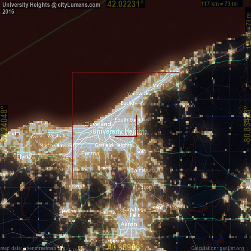
Analysis of University Heights night lights 2016
Square area 10x10 km:
 69.22%
90-99
25%80-89
4.25%70-79
1.36%60-69
0.17%50-59
0%40-49
0%30-39
0%20-29
0%10-19
0%0-9
0%Square area 50x50 km:
17.42%90-99
11.39%80-89
3.91%70-79
4.63%60-69
7%50-59
5.61%40-49
5.22%30-39
4.88%20-29
6.36%10-19
7.47%0-9
26.1%Clear (daylight) street map image can be seen on geolist.org.
Map coordinates:
42° 1' 20.3" North, 82° 14' 25.7" West
41° 29' 52.2" North, 81° 32' 14.5" West
40° 58' 8.6" North, 80° 50' 3.2" West
Some cities around University Heights sort by population:
• Cleveland Heights
2.9 km =1.8 mi,  327°
327°
• Shaker Heights
2.7 km =1.7 mi,  179°
179°
• South Euclid
3.2 km =2 mi,  29°
29°
• East Cleveland
5.2 km =3.2 mi,  318°
318°
• Lyndhurst
4.7 km =2.9 mi,  58°
58°
• Beachwood
4.4 km =2.7 mi,  147°
147°
• Richmond Heights
6.5 km =4 mi,  20°
20°
• Pepper Pike
6.5 km =4 mi,  109°
109°
5174830 (p: 13,202)
Sources (retrieved 2019-11-25):
» Earth at Night: Flat Maps 2012, 2016