Martha Lake night lights from space
Night Light of Martha Lake (Washington) from space (United States) Src. Average luminocity for 10x10km area is 85.3906% and for 50x50km: 28.8585%.
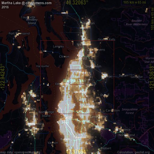
Analysis of Martha Lake night lights 2016
Square area 10x10 km:
 23.58%
90-99
22.87%80-89
11.79%70-79
29.83%60-69
9.09%50-59
2.41%40-49
0.43%30-39
0%20-29
0%10-19
0%0-9
0%Square area 50x50 km:
6.8%90-99
6.28%80-89
2.33%70-79
4.15%60-69
4.87%50-59
3.06%40-49
3.29%30-39
4.25%20-29
5.71%10-19
7.52%0-9
51.75%Clear (daylight) street map image can be seen on geolist.org.
Map coordinates:
48° 19' 14.3" North, 122° 56' 32.7" West
47° 51' 3.3" North, 122° 14' 21.5" West
47° 22' 37" North, 121° 32' 10.2" West
Some cities around Martha Lake sort by population:
• North Creek
5.9 km =3.7 mi,  126°
126°
• Picnic Point-North Lynnwood
4.4 km =2.7 mi,  287°
287°
• Mill Creek
2.8 km =1.7 mi,  68°
68°
• Bothell West
5.1 km =3.2 mi,  181°
181°
• Mill Creek East
4.2 km =2.6 mi,  113°
113°
• Alderwood Manor
4.5 km =2.8 mi,  224°
224°
• Bothell East
6.4 km =4 mi,  140°
140°
• Lake Stickney
3.3 km =2.1 mi,  329°
329°
5802493 (p: 15,473)
Sources (retrieved 2019-11-25):
» Earth at Night: Flat Maps 2012, 2016