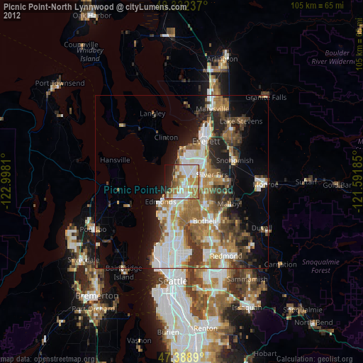
Picnic Point-North Lynnwood night lights from space
Night Light of Picnic Point-North Lynnwood (Washington) from space (United States) Src. Average luminocity for 10x10km area is 71.831% and for 50x50km: 28.1483%.
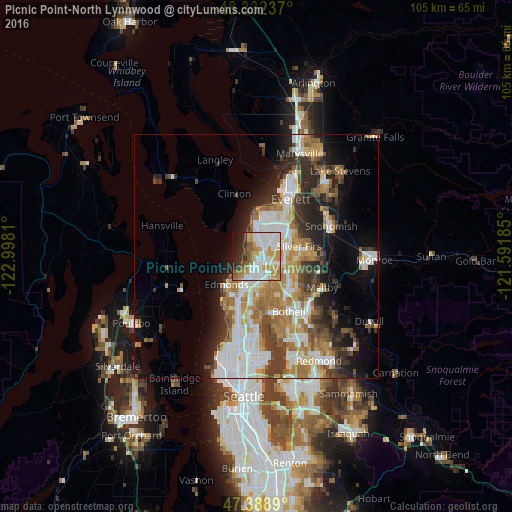
Analysis of Picnic Point-North Lynnwood night lights 2016
Square area 10x10 km:
 21.31%
90-99
21.31%80-89
5.4%70-79
15.48%60-69
6.96%50-59
6.53%40-49
3.27%30-39
3.27%20-29
8.24%10-19
6.68%0-9
1.56%Square area 50x50 km:
6.44%90-99
6.01%80-89
2.34%70-79
4.14%60-69
4.85%50-59
2.99%40-49
3.04%30-39
4.13%20-29
5.68%10-19
8.16%0-9
52.21%Clear (daylight) street map image can be seen on geolist.org.
Map coordinates:
48° 19' 56.5" North, 122° 59' 53.2" West
47° 51' 46" North, 122° 17' 41.9" West
47° 23' 20" North, 121° 35' 30.7" West
Some cities around Picnic Point-North Lynnwood sort by population:
• Lynnwood
4.9 km =3 mi,  197°
197°
• Mountlake Terrace
8.4 km =5.2 mi,  187°
187°
• Mill Creek
6.8 km =4.2 mi,  92°
92°
• Bothell West
7.6 km =4.7 mi,  147°
147°
• Mill Creek East
8.5 km =5.3 mi,  110°
110°
• Martha Lake
4.4 km =2.7 mi, 107°
• Alderwood Manor
4.6 km =2.9 mi,  168°
168°
• Lake Stickney
2.9 km =1.8 mi,  57°
57°
7262110 (p: 22,953)
Sources (retrieved 2019-11-25):
» Earth at Night: Flat Maps 2012, 2016