Mill Creek East night lights from space
Night Light of Mill Creek East (Washington) from space (United States) Src. Average luminocity for 10x10km area is 67.6592% and for 50x50km: 30.0268%.
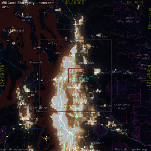
Analysis of Mill Creek East night lights 2016
Square area 10x10 km:
 8.48%
8.48%90-99
8.33%80-89
9.23%70-79
28.87%60-69
14.29%50-59
6.55%40-49
10.12%30-39
10.57%20-29
3.42%10-19
0.15%0-9
0%Square area 50x50 km:
7.28%90-99
6.72%80-89
2.36%70-79
4.04%60-69
5.01%50-59
3.14%40-49
3.57%30-39
4.5%20-29
5.84%10-19
7.39%0-9
50.16%Clear (daylight) street map image can be seen on geolist.org.
Map coordinates:
48° 18' 21.1" North, 122° 53' 26.8" West
47° 50' 9.7" North, 122° 11' 15.6" West
47° 21' 42.8" North, 121° 29' 4.3" West
Some cities around Mill Creek East sort by population:
• North Creek
2 km =1.2 mi,  155°
155°
• Silver Firs
4.1 km =2.5 mi,  36°
36°
• Eastmont
6.8 km =4.2 mi,  3°
3°
• Bothell West
5.2 km =3.2 mi,  229°
229°
• Martha Lake
4.2 km =2.6 mi,  293°
293°
• Maltby
6.5 km =4 mi,  121°
121°
• Alderwood Manor
7.2 km =4.5 mi,  257°
257°
• Bothell East
3.3 km =2.1 mi,  175°
175°
7315418 (p: 15,709)
Sources (retrieved 2019-11-25):
» Earth at Night: Flat Maps 2012, 2016