Bothell East night lights from space
Night Light of Bothell East (Washington) from space (United States) Src. Average luminocity for 10x10km area is 66.8824% and for 50x50km: 32.6171%.
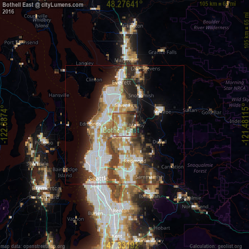
Analysis of Bothell East night lights 2016
Square area 10x10 km:
 9.82%
9.82%90-99
10.57%80-89
7.14%70-79
19.05%60-69
20.39%50-59
7.44%40-49
11.01%30-39
9.67%20-29
4.46%10-19
0.45%0-9
0%Square area 50x50 km:
8.12%90-99
7.29%80-89
2.45%70-79
4.43%60-69
5.41%50-59
3.5%40-49
4.11%30-39
4.98%20-29
5.77%10-19
7.21%0-9
46.73%Clear (daylight) street map image can be seen on geolist.org.
Map coordinates:
48° 16' 35.1" North, 122° 53' 14.6" West
47° 48' 22.7" North, 122° 11' 3.4" West
47° 19' 54.9" North, 121° 28' 52.1" West
Some cities around Bothell East sort by population:
• North Creek
1.6 km =1 mi,  22°
22°
• Kenmore
7 km =4.3 mi,  219°
219°
• Silver Firs
7 km =4.3 mi, 18°
• Mill Creek
6.2 km =3.9 mi,  345°
345°
• Mill Creek East
3.3 km =2.1 mi,  355°
355°
• Martha Lake
6.4 km =4 mi,  320°
320°
• Woodinville
6 km =3.7 mi,  164°
164°
• Maltby
5.3 km =3.3 mi,  91°
91°
7315408 (p: 8,018)
Sources (retrieved 2019-11-25):
» Earth at Night: Flat Maps 2012, 2016