Marblehead night lights from space
Night Light of Marblehead (Massachusetts) from space (United States) Src. Average luminocity for 10x10km area is 41.6746% and for 50x50km: 30.9124%.
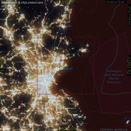
Analysis of Marblehead night lights 2016
Square area 10x10 km:
 7.14%
7.14%90-99
8.25%80-89
5.87%70-79
6.03%60-69
9.52%50-59
4.29%40-49
3.02%30-39
3.33%20-29
12.7%10-19
15.24%0-9
24.6%Square area 50x50 km:
9.19%90-99
6.53%80-89
3.35%70-79
4.02%60-69
4.07%50-59
3.01%40-49
2.76%30-39
3.16%20-29
4.81%10-19
7.29%0-9
51.81%Clear (daylight) street map image can be seen on geolist.org.
Map coordinates:
43° 0' 58.9" North, 71° 33' 39.5" West
42° 30' 0.4" North, 70° 51' 28.2" West
41° 58' 46.4" North, 70° 9' 17" West
Some cities around Marblehead sort by population:
• Lynn
8.4 km =5.2 mi,  243°
243°
• Peabody
6.6 km =4.1 mi,  298°
298°
• South Peabody
7.6 km =4.7 mi,  278°
278°
• Salem
3.9 km =2.4 mi, 304°
• Beverly
6.7 km =4.2 mi,  344°
344°
• Beverly Cove
5.9 km =3.7 mi,  3°
3°
• Danvers
10.2 km =6.3 mi,  324°
324°
• Swampscott
5.9 km =3.7 mi, 236°
4943097 (p: 19,808)
Sources (retrieved 2019-11-25):
» Earth at Night: Flat Maps 2012, 2016