Manhattan night lights from space
Night Light of Manhattan (Illinois) from space (United States) Src. Average luminocity for 10x10km area is 20.5017% and for 50x50km: 43.3149%.
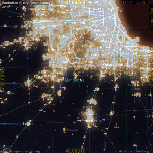
Analysis of Manhattan night lights 2016
Square area 10x10 km:
 0.68%
0.68%90-99
0.85%80-89
3.06%70-79
2.72%60-69
0.85%50-59
4.08%40-49
3.23%30-39
2.89%20-29
18.03%10-19
21.6%0-9
42.01%Square area 50x50 km:
7.29%90-99
9.12%80-89
7.76%70-79
7.8%60-69
8.42%50-59
6.26%40-49
3.09%30-39
3.42%20-29
5.5%10-19
9.95%0-9
31.39%Clear (daylight) street map image can be seen on geolist.org.
Map coordinates:
41° 56' 51.5" North, 88° 41' 20.5" West
41° 25' 21.1" North, 87° 59' 9.2" West
40° 53' 35.3" North, 87° 16' 58" West
Some cities around Manhattan sort by population:
• Joliet
14 km =8.7 mi,  324°
324°
• New Lenox
10.1 km =6.3 mi,  9°
9°
• Lockport
19.5 km =12.1 mi,  342°
342°
• Crest Hill
17.4 km =10.8 mi,  327°
327°
• Mokena
14.1 km =8.8 mi,  34°
34°
• Frankfort
14 km =8.7 mi,  54°
54°
• Frankfort Square
18.6 km =11.6 mi, 54°
• Wilmington
18.5 km =11.5 mi,  226°
226°
4900961 (p: 7,400)
Sources (retrieved 2019-11-25):
» Earth at Night: Flat Maps 2012, 2016