Wilmington night lights from space
Night Light of Wilmington (Illinois) from space (United States) Src. Average luminocity for 10x10km area is 24.4253% and for 50x50km: 22.7108%.
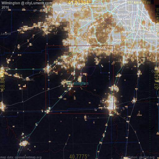
Analysis of Wilmington night lights 2016
Square area 10x10 km:
 0.65%
0.65%90-99
1.79%80-89
6.17%70-79
5.19%60-69
3.57%50-59
0.16%40-49
1.95%30-39
2.92%20-29
4.87%10-19
42.21%0-9
30.52%Square area 50x50 km:
2.98%90-99
3.2%80-89
3.89%70-79
3.2%60-69
3.77%50-59
3.7%40-49
3.35%30-39
3.18%20-29
5.56%10-19
12.15%0-9
55.02%Clear (daylight) street map image can be seen on geolist.org.
Map coordinates:
41° 50' 1.8" North, 88° 50' 59.5" West
41° 18' 28.1" North, 88° 8' 48.2" West
40° 46' 39" North, 87° 26' 37" West
Some cities around Wilmington sort by population:
• Joliet
24.7 km =15.3 mi,  12°
12°
• Shorewood
24 km =14.9 mi,  348°
348°
• Morris
23.6 km =14.7 mi,  283°
283°
• Channahon
15.2 km =9.4 mi,  333°
333°
• Minooka
19 km =11.8 mi, 329°
• Manhattan
18.5 km =11.5 mi,  46°
46°
• Braidwood
7.3 km =4.5 mi,  229°
229°
• Coal City
11.8 km =7.3 mi,  259°
259°
4916740 (p: 5,694)
Sources (retrieved 2019-11-25):
» Earth at Night: Flat Maps 2012, 2016