Mandeville night lights from space
Night Light of Mandeville (Louisiana) from space (United States) Src. Average luminocity for 10x10km area is 46.6374% and for 50x50km: 14.3366%.
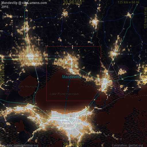
Analysis of Mandeville night lights 2016
Square area 10x10 km:
 5.31%
5.31%90-99
8.42%80-89
7.33%70-79
12.09%60-69
13%50-59
1.83%40-49
2.93%30-39
2.2%20-29
11.17%10-19
22.89%0-9
12.82%Square area 50x50 km:
0.73%90-99
1.11%80-89
2.57%70-79
2.71%60-69
4.19%50-59
1.36%40-49
1.89%30-39
2.41%20-29
4.06%10-19
10.43%0-9
68.54%Clear (daylight) street map image can be seen on geolist.org.
Map coordinates:
30° 57' 47.1" North, 90° 46' 7.5" West
30° 21' 29.7" North, 90° 3' 56.3" West
29° 44' 58.8" North, 89° 21' 45" West
Some cities around Mandeville sort by population:
• Metairie
42.4 km =26.3 mi,  191°
191°
• Slidell
28.8 km =17.9 mi,  108°
108°
• Hammond
41.4 km =25.7 mi,  293°
293°
• Picayune
41.6 km =25.8 mi,  63°
63°
• Covington
13.5 km =8.4 mi,  345°
345°
• Lacombe
12.8 km =8 mi, 112°
• Ponchatoula
37.1 km =23.1 mi,  283°
283°
• Eden Isle
29.4 km =18.3 mi,  119°
119°
4332455 (p: 12,345)
Sources (retrieved 2019-11-25):
» Earth at Night: Flat Maps 2012, 2016