Picayune night lights from space
Night Light of Picayune (Mississippi) from space (United States) Src. Average luminocity for 10x10km area is 47.4084% and for 50x50km: 11.3625%.
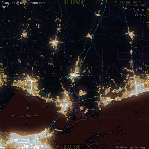
Analysis of Picayune night lights 2016
Square area 10x10 km:
 5.49%
5.49%90-99
4.58%80-89
8.42%70-79
7.88%60-69
9.16%50-59
6.41%40-49
11.17%30-39
11.17%20-29
12.09%10-19
21.25%0-9
2.38%Square area 50x50 km:
0.58%90-99
0.48%80-89
1.96%70-79
1.79%60-69
2.37%50-59
1.2%40-49
2.37%30-39
2.77%20-29
2.64%10-19
9.73%0-9
74.1%Clear (daylight) street map image can be seen on geolist.org.
Map coordinates:
31° 7' 45.6" North, 90° 22' 51.6" West
30° 31' 32" North, 89° 40' 40.4" West
29° 55' 4.8" North, 88° 58' 29.1" West
Some cities around Picayune sort by population:
• Slidell
29.5 km =18.3 mi,  199°
199°
• Carriere
10.4 km =6.5 mi,  13°
13°
• Bogalusa
33.7 km =20.9 mi,  331°
331°
• Covington
40.9 km =25.4 mi,  262°
262°
• Lacombe
34.7 km =21.6 mi,  227°
227°
• Diamondhead
33.4 km =20.8 mi,  115°
115°
• Eden Isle
35 km =21.7 mi, 199°
• Waveland
39.3 km =24.4 mi,  132°
132°
4440975 (p: 10,675)
Sources (retrieved 2019-11-25):
» Earth at Night: Flat Maps 2012, 2016