Ponchatoula night lights from space
Night Light of Ponchatoula (Louisiana) from space (United States) Src. Average luminocity for 10x10km area is 59.5037% and for 50x50km: 18.8522%.
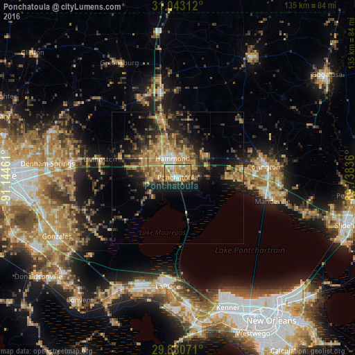
Analysis of Ponchatoula night lights 2016
Square area 10x10 km:
 7.51%
7.51%90-99
6.41%80-89
17.4%70-79
19.23%60-69
12.09%50-59
3.11%40-49
0.92%30-39
2.38%20-29
14.84%10-19
15.93%0-9
0.18%Square area 50x50 km:
0.9%90-99
0.98%80-89
4.14%70-79
3.84%60-69
4.61%50-59
2.12%40-49
3.27%30-39
4.06%20-29
5.75%10-19
10%0-9
60.32%Clear (daylight) street map image can be seen on geolist.org.
Map coordinates:
31° 2' 35.2" North, 91° 8' 40.6" West
30° 26' 19.7" North, 90° 26' 29.3" West
29° 49' 50.6" North, 89° 44' 18.1" West
Some cities around Ponchatoula sort by population:
• Laplace
41.5 km =25.8 mi,  185°
185°
• Hammond
7.6 km =4.7 mi,  344°
344°
• Mandeville
37.1 km =23.1 mi,  103°
103°
• Denham Springs
49.8 km =30.9 mi,  276°
276°
• Covington
32.9 km =20.4 mi,  82°
82°
• Reserve
44.1 km =27.4 mi, 193°
• Lacombe
49.8 km =30.9 mi,  106°
106°
• Walker
40.6 km =25.2 mi, 277°
4337775 (p: 7,068)
Sources (retrieved 2019-11-25):
» Earth at Night: Flat Maps 2012, 2016