Covington night lights from space
Night Light of Covington (Louisiana) from space (United States) Src. Average luminocity for 10x10km area is 68.8626% and for 50x50km: 14.2788%.
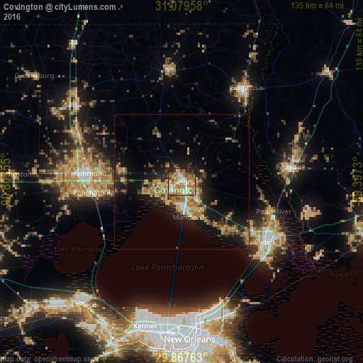
Analysis of Covington night lights 2016
Square area 10x10 km:
 8.24%
8.24%90-99
10.81%80-89
15.57%70-79
13.74%60-69
27.66%50-59
5.68%40-49
5.68%30-39
4.21%20-29
7.14%10-19
1.28%0-9
0%Square area 50x50 km:
0.67%90-99
1.04%80-89
2.52%70-79
2.64%60-69
3.92%50-59
1.38%40-49
2.1%30-39
2.65%20-29
4.54%10-19
10.33%0-9
68.2%Clear (daylight) street map image can be seen on geolist.org.
Map coordinates:
31° 4' 46.5" North, 90° 48' 12.8" West
30° 28' 31.8" North, 90° 6' 1.5" West
29° 52' 3.5" North, 89° 23' 50.3" West
Some cities around Covington sort by population:
• Slidell
37.9 km =23.5 mi,  126°
126°
• Hammond
34.9 km =21.7 mi,  275°
275°
• Mandeville
13.5 km =8.4 mi,  165°
165°
• Bogalusa
42.6 km =26.5 mi,  34°
34°
• Picayune
40.9 km =25.4 mi,  82°
82°
• Lacombe
23.5 km =14.6 mi,  140°
140°
• Ponchatoula
32.9 km =20.4 mi,  262°
262°
• Eden Isle
39.9 km =24.8 mi, 133°
4321005 (p: 9,928)
Sources (retrieved 2019-11-25):
» Earth at Night: Flat Maps 2012, 2016