Lyons night lights from space
Night Light of Lyons (Illinois) from space (United States) Src. Average luminocity for 10x10km area is 98.3424% and for 50x50km: 85.5736%.
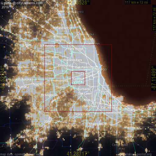
Analysis of Lyons night lights 2016
Square area 10x10 km:
 66.67%
90-99
28.48%80-89
4.24%70-79
0.61%60-69
0%50-59
0%40-49
0%30-39
0%20-29
0%10-19
0%0-9
0%Square area 50x50 km:
46.19%90-99
21.2%80-89
9.05%70-79
6.21%60-69
4.34%50-59
3.52%40-49
1.81%30-39
1.18%20-29
0.94%10-19
1.38%0-9
4.19%Clear (daylight) street map image can be seen on geolist.org.
Map coordinates:
42° 20' 7" North, 88° 31' 16.5" West
41° 48' 48.1" North, 87° 49' 5.2" West
41° 17' 13.8" North, 87° 6' 54" West
Some cities around Lyons sort by population:
• Berwyn
4.6 km =2.9 mi,  26°
26°
• Brookfield
3 km =1.9 mi,  292°
292°
• La Grange
4.3 km =2.7 mi,  257°
257°
• La Grange Park
4.3 km =2.7 mi,  303°
303°
• Summit
2.9 km =1.8 mi,  167°
167°
• Riverside
2.4 km =1.5 mi,  350°
350°
• Stickney
3.1 km =1.9 mi,  72°
72°
• North Riverside
3.3 km =2.1 mi, 352°
4900749 (p: 10,722)
Sources (retrieved 2019-11-25):
» Earth at Night: Flat Maps 2012, 2016