Brookfield night lights from space
Night Light of Brookfield (Illinois) from space (United States) Src. Average luminocity for 10x10km area is 96.0682% and for 50x50km: 88.0135%.
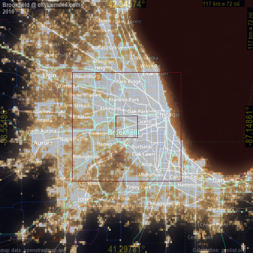
Analysis of Brookfield night lights 2016
Square area 10x10 km:
 44.24%
90-99
40.91%80-89
11.06%70-79
3.79%60-69
0%50-59
0%40-49
0%30-39
0%20-29
0%10-19
0%0-9
0%Square area 50x50 km:
46.45%90-99
22.39%80-89
10.23%70-79
6.91%60-69
4.31%50-59
3.16%40-49
1.61%30-39
0.95%20-29
0.84%10-19
0.99%0-9
2.14%Clear (daylight) street map image can be seen on geolist.org.
Map coordinates:
42° 20' 44.7" North, 88° 33' 17.5" West
41° 49' 26.1" North, 87° 51' 6.2" West
41° 17' 52.1" North, 87° 8' 55" West
Some cities around Brookfield sort by population:
• Westchester
3.9 km =2.4 mi,  319°
319°
• La Grange
2.6 km =1.6 mi,  214°
214°
• La Grange Park
1.5 km =0.9 mi,  325°
325°
• Western Springs
4.3 km =2.7 mi,  248°
248°
• Lyons
3 km =1.9 mi,  112°
112°
• Riverside
2.7 km =1.7 mi,  62°
62°
• Broadview
4.4 km =2.7 mi,  358°
358°
• North Riverside
3.2 km =2 mi,  48°
48°
4885689 (p: 18,944)
Sources (retrieved 2019-11-25):
» Earth at Night: Flat Maps 2012, 2016