Lynnfield night lights from space
Night Light of Lynnfield (Massachusetts) from space (United States) Src. Average luminocity for 10x10km area is 69.9302% and for 50x50km: 47.531%.
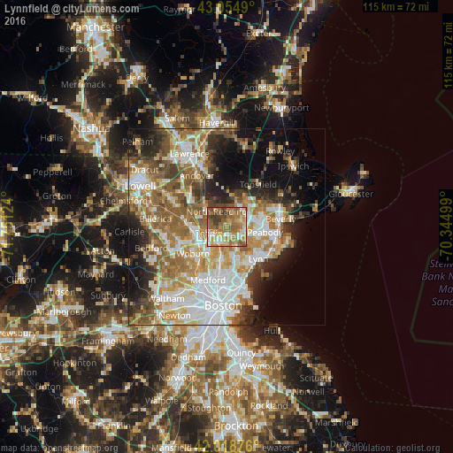
Analysis of Lynnfield night lights 2016
Square area 10x10 km:
 7.94%
7.94%90-99
11.27%80-89
11.27%70-79
16.83%60-69
23.97%50-59
15.24%40-49
7.14%30-39
6.35%20-29
0%10-19
0%0-9
0%Square area 50x50 km:
11.08%90-99
9.55%80-89
5.53%70-79
6.72%60-69
8.45%50-59
8.18%40-49
5.3%30-39
4.74%20-29
7.09%10-19
8.64%0-9
24.71%Clear (daylight) street map image can be seen on geolist.org.
Map coordinates:
43° 3' 17.6" North, 71° 45' 4.5" West
42° 32' 20.3" North, 71° 2' 53.2" West
42° 1' 7.5" North, 70° 20' 42" West
Some cities around Lynnfield sort by population:
• South Peabody
8.7 km =5.4 mi,  111°
111°
• Melrose
9.1 km =5.7 mi,  189°
189°
• Saugus
8.8 km =5.5 mi,  159°
159°
• Wakefield
4.1 km =2.5 mi,  209°
209°
• Reading
4.1 km =2.5 mi,  249°
249°
• Stoneham
7.8 km =4.8 mi, 212°
• North Reading
4.7 km =2.9 mi,  328°
328°
• Middleton
6.8 km =4.2 mi,  22°
22°
4942821 (p: 11,596)
Sources (retrieved 2019-11-25):
» Earth at Night: Flat Maps 2012, 2016