Lugoff night lights from space
Night Light of Lugoff (South Carolina) from space (United States) Src. Average luminocity for 10x10km area is 39.4725% and for 50x50km: 18.5357%.
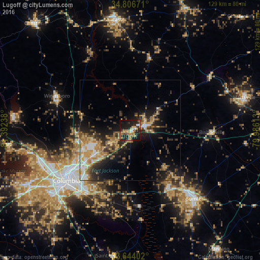
Analysis of Lugoff night lights 2016
Square area 10x10 km:
 1.65%
1.65%90-99
3.66%80-89
5.86%70-79
8.61%60-69
11.54%50-59
3.85%40-49
1.1%30-39
8.79%20-29
22.34%10-19
30.04%0-9
2.56%Square area 50x50 km:
1.66%90-99
1.98%80-89
2.88%70-79
3.66%60-69
3.44%50-59
1.97%40-49
2.56%30-39
4.18%20-29
5.83%10-19
10.55%0-9
61.29%Clear (daylight) street map image can be seen on geolist.org.
Map coordinates:
34° 48' 24.2" North, 81° 23' 32.6" West
34° 13' 38.5" North, 80° 41' 21.3" West
33° 38' 38.5" North, 79° 59' 10.1" West
Some cities around Lugoff sort by population:
• Columbia
40.6 km =25.2 mi,  231°
231°
• Saint Andrews
45.3 km =28.1 mi,  243°
243°
• West Columbia
43.9 km =27.3 mi, 233°
• Dentsville
30.7 km =19.1 mi, 233°
• Cayce
45.8 km =28.5 mi, 230°
• Forest Acres
36.1 km =22.4 mi, 230°
• Woodfield
29 km =18 mi, 229°
• Camden
7.9 km =4.9 mi,  74°
74°
4050356 (p: 7,434)
Sources (retrieved 2019-11-25):
» Earth at Night: Flat Maps 2012, 2016