Forest Acres night lights from space
Night Light of Forest Acres (South Carolina) from space (United States) Src. Average luminocity for 10x10km area is 97.8881% and for 50x50km: 48.3929%.
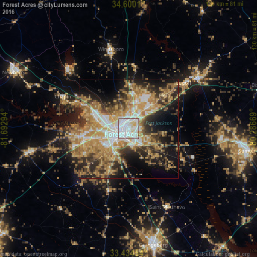
Analysis of Forest Acres night lights 2016
Square area 10x10 km:
 59.97%
90-99
31.64%80-89
6.99%70-79
1.4%60-69
0%50-59
0%40-49
0%30-39
0%20-29
0%10-19
0%0-9
0%Square area 50x50 km:
8.1%90-99
7.42%80-89
8.45%70-79
9.69%60-69
10.09%50-59
5.22%40-49
5.17%30-39
7.42%20-29
9.12%10-19
12.21%0-9
17.12%Clear (daylight) street map image can be seen on geolist.org.
Map coordinates:
34° 36' 0.4" North, 81° 41' 34.6" West
34° 1' 9.6" North, 80° 59' 23.3" West
33° 26' 4.3" North, 80° 17' 12.1" West
Some cities around Forest Acres sort by population:
• Columbia
4.6 km =2.9 mi,  243°
243°
• Saint Andrews
13.2 km =8.2 mi,  282°
282°
• West Columbia
8.3 km =5.2 mi,  249°
249°
• Seven Oaks
14.8 km =9.2 mi, 282°
• Dentsville
5.8 km =3.6 mi,  30°
30°
• Cayce
9.8 km =6.1 mi,  232°
232°
• Oak Grove
14.7 km =9.1 mi, 253°
• Woodfield
7 km =4.3 mi,  50°
50°
4578841 (p: 10,615)
Sources (retrieved 2019-11-25):
» Earth at Night: Flat Maps 2012, 2016