Cayce night lights from space
Night Light of Cayce (South Carolina) from space (United States) Src. Average luminocity for 10x10km area is 90.9423% and for 50x50km: 49.3231%.
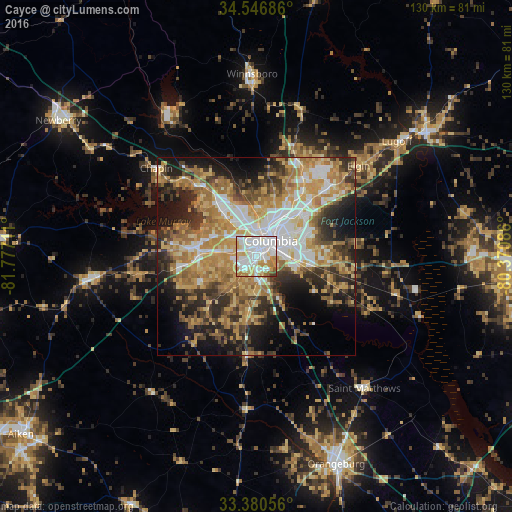
Analysis of Cayce night lights 2016
Square area 10x10 km:
 36.89%
90-99
30.59%80-89
12.94%70-79
12.06%60-69
4.55%50-59
1.57%40-49
1.05%30-39
0.35%20-29
0%10-19
0%0-9
0%Square area 50x50 km:
8.26%90-99
7.63%80-89
8.53%70-79
9.74%60-69
10.74%50-59
5.22%40-49
5.39%30-39
7.71%20-29
9.25%10-19
11.55%0-9
15.99%Clear (daylight) street map image can be seen on geolist.org.
Map coordinates:
34° 32' 48.7" North, 81° 46' 37.6" West
33° 57' 56.6" North, 81° 4' 26.3" West
33° 22' 50" North, 80° 22' 15.1" West
Some cities around Cayce sort by population:
• Columbia
5.3 km =3.3 mi,  42°
42°
• Saint Andrews
10.2 km =6.3 mi,  330°
330°
• Lexington
15.1 km =9.4 mi,  276°
276°
• West Columbia
3.1 km =1.9 mi,  0°
0°
• Seven Oaks
11.4 km =7.1 mi,  324°
324°
• Dentsville
15.3 km =9.5 mi, 44°
• Forest Acres
9.8 km =6.1 mi,  52°
52°
• Oak Grove
6.6 km =4.1 mi, 284°
4573888 (p: 13,619)
Sources (retrieved 2019-11-25):
» Earth at Night: Flat Maps 2012, 2016