Lucas Valley-Marinwood night lights from space
Night Light of Lucas Valley-Marinwood (California) from space (United States) Src. Average luminocity for 10x10km area is 31.5795% and for 50x50km: 13.5105%.
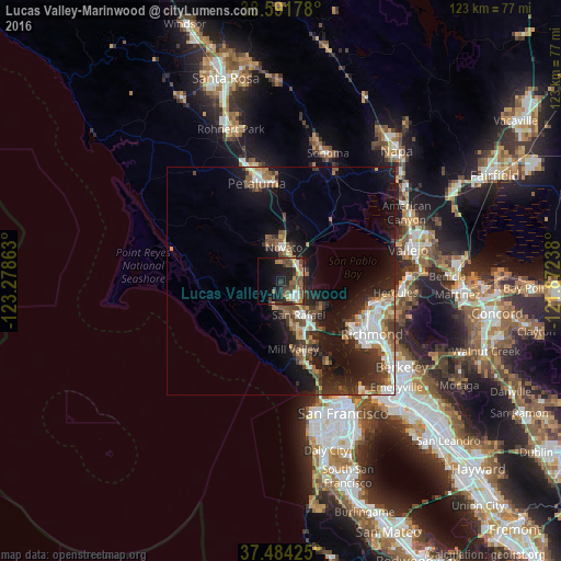
Analysis of Lucas Valley-Marinwood night lights 2016
Square area 10x10 km:
 3.73%
3.73%90-99
3.25%80-89
1.79%70-79
5.84%60-69
5.03%50-59
6.01%40-49
8.6%30-39
6.33%20-29
9.09%10-19
20.13%0-9
30.19%Square area 50x50 km:
2.05%90-99
2.05%80-89
0.74%70-79
1.64%60-69
1.8%50-59
2.1%40-49
2.52%30-39
2.62%20-29
4.09%10-19
11.61%0-9
68.78%Clear (daylight) street map image can be seen on geolist.org.
Map coordinates:
38° 35' 30.4" North, 123° 16' 43.1" West
38° 2' 24.4" North, 122° 34' 31.8" West
37° 29' 3.3" North, 121° 52' 20.6" West
Some cities around Lucas Valley-Marinwood sort by population:
• San Rafael
8.4 km =5.2 mi,  152°
152°
• Novato
7.5 km =4.7 mi,  3°
3°
• Mill Valley
15.1 km =9.4 mi,  169°
169°
• San Anselmo
7.4 km =4.6 mi, 170°
• Larkspur
12.3 km =7.6 mi,  163°
163°
• Corte Madera
13.4 km =8.3 mi, 161°
• Fairfax
6 km =3.7 mi,  191°
191°
• Kentfield
9.9 km =6.2 mi, 170°
7261199 (p: 6,094)
Sources (retrieved 2019-11-25):
» Earth at Night: Flat Maps 2012, 2016