Fairfax night lights from space
Night Light of Fairfax (California) from space (United States) Src. Average luminocity for 10x10km area is 27.4205% and for 50x50km: 14.6941%.
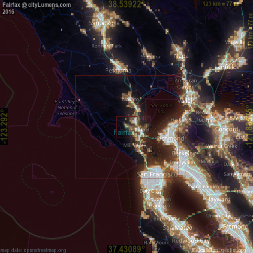
Analysis of Fairfax night lights 2016
Square area 10x10 km:
 2.92%
2.92%90-99
2.92%80-89
2.11%70-79
6.33%60-69
2.92%50-59
4.71%40-49
9.9%30-39
5.19%20-29
5.19%10-19
15.42%0-9
42.37%Square area 50x50 km:
3.19%90-99
2.42%80-89
0.7%70-79
1.64%60-69
1.6%50-59
2%40-49
3.01%30-39
2.66%20-29
4.17%10-19
9.84%0-9
68.77%Clear (daylight) street map image can be seen on geolist.org.
Map coordinates:
38° 32' 21.2" North, 123° 17' 31.2" West
37° 59' 13.7" North, 122° 35' 19.9" West
37° 25' 51.2" North, 121° 53' 8.7" West
Some cities around Fairfax sort by population:
• San Rafael
5.3 km =3.3 mi,  106°
106°
• Mill Valley
9.8 km =6.1 mi,  156°
156°
• San Anselmo
2.8 km =1.7 mi,  120°
120°
• Larkspur
7.5 km =4.7 mi,  141°
141°
• Corte Madera
8.7 km =5.4 mi, 141°
• Kentfield
4.8 km =3 mi, 144°
• Lucas Valley-Marinwood
6 km =3.7 mi,  11°
11°
• Strawberry
12.2 km =7.6 mi,  145°
145°
5347322 (p: 7,626)
Sources (retrieved 2019-11-25):
» Earth at Night: Flat Maps 2012, 2016