Kentfield night lights from space
Night Light of Kentfield (California) from space (United States) Src. Average luminocity for 10x10km area is 39.1542% and for 50x50km: 19.8896%.
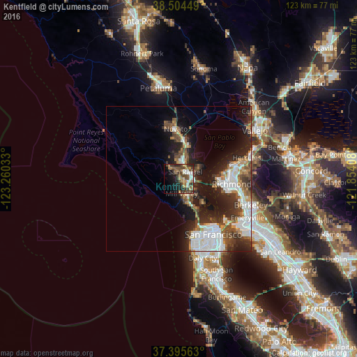
Analysis of Kentfield night lights 2016
Square area 10x10 km:
 5.68%
5.68%90-99
3.9%80-89
2.27%70-79
9.25%60-69
5.68%50-59
5.68%40-49
13.8%30-39
7.95%20-29
9.25%10-19
15.91%0-9
20.62%Square area 50x50 km:
5.01%90-99
3.78%80-89
0.92%70-79
2.15%60-69
1.94%50-59
2.58%40-49
3.64%30-39
3.27%20-29
5.72%10-19
10.77%0-9
60.21%Clear (daylight) street map image can be seen on geolist.org.
Map coordinates:
38° 30' 16.2" North, 123° 15' 37.2" West
37° 57' 7.7" North, 122° 33' 25.9" West
37° 23' 44.3" North, 121° 51' 14.7" West
Some cities around Kentfield sort by population:
• San Rafael
3.3 km =2.1 mi,  43°
43°
• Mill Valley
5.2 km =3.2 mi,  168°
168°
• San Anselmo
2.5 km =1.6 mi,  351°
351°
• Larkspur
2.8 km =1.7 mi,  136°
136°
• Corte Madera
3.9 km =2.4 mi, 138°
• Fairfax
4.8 km =3 mi,  324°
324°
• Tamalpais Valley
8.1 km =5 mi, 172°
• Strawberry
7.5 km =4.7 mi,  145°
145°
5362864 (p: 6,485)
Sources (retrieved 2019-11-25):
» Earth at Night: Flat Maps 2012, 2016