Little Cottonwood Creek Valley night lights from space
Night Light of Little Cottonwood Creek Valley (Utah) from space (United States) Src. Average luminocity for 10x10km area is 76.9903% and for 50x50km: 36.6931%.
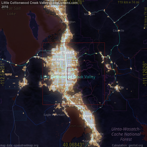
Analysis of Little Cottonwood Creek Valley night lights 2016
Square area 10x10 km:
 28.41%
90-99
21.92%80-89
8.28%70-79
6.98%60-69
9.42%50-59
7.63%40-49
2.11%30-39
4.06%20-29
7.31%10-19
3.9%0-9
0%Square area 50x50 km:
9.63%90-99
9.36%80-89
5.76%70-79
4.23%60-69
4.23%50-59
3.85%40-49
2.58%30-39
2.9%20-29
5.43%10-19
7.9%0-9
44.14%Clear (daylight) street map image can be seen on geolist.org.
Map coordinates:
41° 8' 9.9" North, 112° 31' 57" West
40° 36' 15.8" North, 111° 49' 45.8" West
40° 4' 6.3" North, 111° 7' 34.5" West
Some cities around Little Cottonwood Creek Valley sort by population:
• Sandy Hills
3.2 km =2 mi,  214°
214°
• Sandy
4.8 km =3 mi,  252°
252°
• Murray
8.5 km =5.3 mi,  324°
324°
• Draper
9.3 km =5.8 mi,  198°
198°
• Cottonwood Heights
2.3 km =1.4 mi,  43°
43°
• Midvale
6 km =3.7 mi,  277°
277°
• Holladay
7.2 km =4.5 mi,  3°
3°
• White City
5.2 km =3.2 mi, 214°
5555083 (p: 8,285)
Sources (retrieved 2019-11-25):
» Earth at Night: Flat Maps 2012, 2016