Lexington Park night lights from space
Night Light of Lexington Park (Maryland) from space (United States) Src. Average luminocity for 10x10km area is 50.6888% and for 50x50km: 6.3948%.
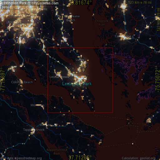
Analysis of Lexington Park night lights 2016
Square area 10x10 km:
 7.31%
7.31%90-99
8.5%80-89
7.48%70-79
10.88%60-69
5.61%50-59
8.5%40-49
4.93%30-39
9.18%20-29
17.86%10-19
18.03%0-9
1.7%Square area 50x50 km:
0.47%90-99
0.51%80-89
0.84%70-79
1%60-69
0.91%50-59
0.97%40-49
0.7%30-39
1.69%20-29
2.34%10-19
5.12%0-9
85.45%Clear (daylight) street map image can be seen on geolist.org.
Map coordinates:
38° 49' 0.3" North, 77° 9' 25.1" West
38° 16' 0.4" North, 76° 27' 13.8" West
37° 42' 45.5" North, 75° 45' 2.6" West
Some cities around Lexington Park sort by population:
• Waldorf
58 km =36 mi,  313°
313°
• Saint Charles
56.4 km =35 mi, 311°
• St. Charles
55.8 km =34.7 mi, 312°
• Cambridge
46.4 km =28.8 mi,  44°
44°
• California
6 km =3.7 mi, 308°
• Chesapeake Ranch Estates
9.4 km =5.8 mi,  19°
19°
• La Plata
54 km =33.6 mi,  302°
302°
• Chesapeake Beach
47.2 km =29.3 mi,  351°
351°
4360592 (p: 11,626)
Sources (retrieved 2019-11-25):
» Earth at Night: Flat Maps 2012, 2016