La Plata night lights from space
Night Light of La Plata (Maryland) from space (United States) Src. Average luminocity for 10x10km area is 29.2013% and for 50x50km: 19.4485%.
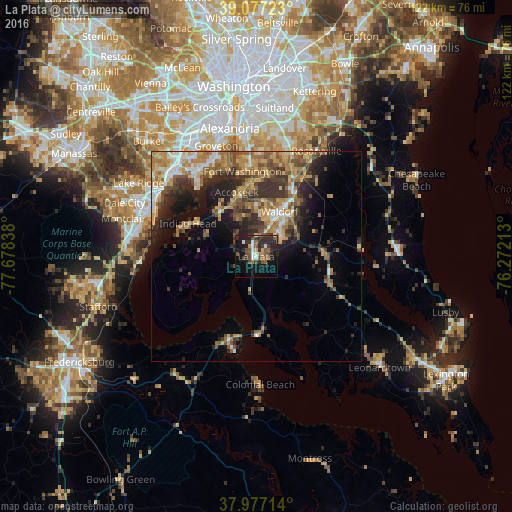
Analysis of La Plata night lights 2016
Square area 10x10 km:
 3.41%
3.41%90-99
2.44%80-89
1.46%70-79
2.6%60-69
3.57%50-59
6.66%40-49
8.12%30-39
7.31%20-29
14.61%10-19
23.21%0-9
26.62%Square area 50x50 km:
2.04%90-99
1.88%80-89
2.93%70-79
3.48%60-69
3.65%50-59
3.67%40-49
3.08%30-39
4.23%20-29
5.65%10-19
7.59%0-9
61.8%Clear (daylight) street map image can be seen on geolist.org.
Map coordinates:
39° 4' 38" North, 77° 40' 42.2" West
38° 31' 45.4" North, 76° 58' 30.9" West
37° 58' 37.7" North, 76° 16' 19.7" West
Some cities around La Plata sort by population:
• Waldorf
11 km =6.8 mi,  16°
16°
• Saint Charles
8.8 km =5.5 mi, 21°
• St. Charles
9.7 km =6 mi,  26°
26°
• Fort Washington
20.2 km =12.6 mi,  348°
348°
• Bennsville
9.5 km =5.9 mi,  340°
340°
• Accokeek
16.1 km =10 mi, 343°
• Bryans Road
13.8 km =8.6 mi,  321°
321°
• Brandywine
21.7 km =13.5 mi, 30°
4360103 (p: 9,125)
Sources (retrieved 2019-11-25):
» Earth at Night: Flat Maps 2012, 2016