Lantana night lights from space
Night Light of Lantana (Texas) from space (United States) Src. Average luminocity for 10x10km area is 61.4341% and for 50x50km: 57.565%.
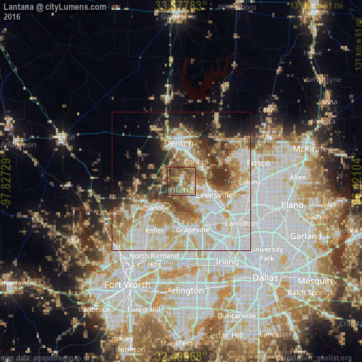
Analysis of Lantana night lights 2016
Square area 10x10 km:
 3.48%
3.48%90-99
5.49%80-89
7.33%70-79
11.54%60-69
20.88%50-59
26.56%40-49
16.67%30-39
6.04%20-29
2.01%10-19
0%0-9
0%Square area 50x50 km:
13.66%90-99
14.52%80-89
9.56%70-79
7.95%60-69
8.08%50-59
6.92%40-49
5.12%30-39
5.01%20-29
5.61%10-19
7.4%0-9
16.17%Clear (daylight) street map image can be seen on geolist.org.
Map coordinates:
33° 40' 40.2" North, 97° 49' 38.2" West
33° 5' 26.6" North, 97° 7' 27" West
32° 29' 58.8" North, 96° 25' 15.7" West
Some cities around Lantana sort by population:
• Denton
13.8 km =8.6 mi,  356°
356°
• Lewisville
13.1 km =8.1 mi,  112°
112°
• Flower Mound
8.8 km =5.5 mi,  163°
163°
• Corinth
9 km =5.6 mi,  38°
38°
• Highland Village
7.2 km =4.5 mi,  89°
89°
• Trophy Club
11.7 km =7.3 mi,  208°
208°
• Lake Dallas
9.7 km =6 mi,  70°
70°
• Roanoke
13.5 km =8.4 mi,  224°
224°
7315364 (p: 6,874)
Sources (retrieved 2019-11-25):
» Earth at Night: Flat Maps 2012, 2016