Bryans Road night lights from space
Night Light of Bryans Road (Maryland) from space (United States) Src. Average luminocity for 10x10km area is 28.9318% and for 50x50km: 41.8894%.
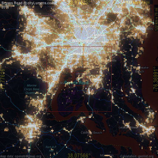
Analysis of Bryans Road night lights 2016
Square area 10x10 km:
 0.81%
0.81%90-99
0.49%80-89
6.01%70-79
3.73%60-69
4.38%50-59
5.68%40-49
6.98%30-39
5.36%20-29
7.31%10-19
45.13%0-9
14.12%Square area 50x50 km:
8.33%90-99
7.84%80-89
6.46%70-79
8.21%60-69
7.13%50-59
5.43%40-49
4.23%30-39
4.98%20-29
6.23%10-19
8.11%0-9
33.04%Clear (daylight) street map image can be seen on geolist.org.
Map coordinates:
39° 10' 27.3" North, 77° 46' 34.2" West
38° 37' 37.4" North, 77° 4' 22.9" West
38° 4' 32.4" North, 76° 22' 11.7" West
Some cities around Bryans Road sort by population:
• Waldorf
11.6 km =7.2 mi,  91°
91°
• Fort Washington
9.9 km =6.2 mi,  25°
25°
• Woodlawn
11.2 km =7 mi,  332°
332°
• Fort Hunt
11.8 km =7.3 mi,  6°
6°
• Mount Vernon
10 km =6.2 mi,  346°
346°
• Bennsville
5.6 km =3.5 mi,  110°
110°
• Accokeek
6 km =3.7 mi,  40°
40°
• Fort Belvoir
11.4 km =7.1 mi, 326°
4349727 (p: 7,244)
Sources (retrieved 2019-11-25):
» Earth at Night: Flat Maps 2012, 2016