Bennsville night lights from space
Night Light of Bennsville (Maryland) from space (United States) Src. Average luminocity for 10x10km area is 37.5422% and for 50x50km: 35.1043%.
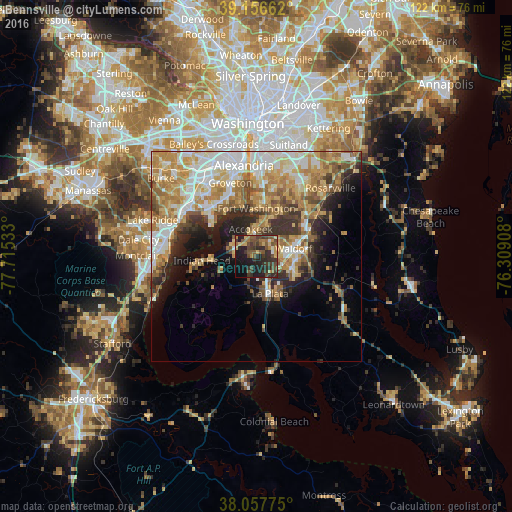
Analysis of Bennsville night lights 2016
Square area 10x10 km:
 0.81%
0.81%90-99
0.97%80-89
6.01%70-79
3.9%60-69
6.17%50-59
10.39%40-49
12.5%30-39
14.29%20-29
17.05%10-19
21.75%0-9
6.17%Square area 50x50 km:
6.48%90-99
6.29%80-89
5.61%70-79
6.72%60-69
5.85%50-59
4.75%40-49
3.7%30-39
4.46%20-29
5.82%10-19
8.03%0-9
42.28%Clear (daylight) street map image can be seen on geolist.org.
Map coordinates:
39° 9' 23.8" North, 77° 42' 55.2" West
38° 36' 33.4" North, 77° 0' 43.9" West
38° 3' 27.9" North, 76° 18' 32.7" West
Some cities around Bennsville sort by population:
• Waldorf
6.6 km =4.1 mi,  75°
75°
• Saint Charles
6.4 km =4 mi,  96°
96°
• St. Charles
7.6 km =4.7 mi,  91°
91°
• Fort Washington
10.9 km =6.8 mi,  355°
355°
• Mount Vernon
14 km =8.7 mi,  326°
326°
• Accokeek
6.6 km =4.1 mi,  347°
347°
• La Plata
9.5 km =5.9 mi,  160°
160°
• Bryans Road
5.6 km =3.5 mi,  290°
290°
4348418 (p: 11,923)
Sources (retrieved 2019-11-25):
» Earth at Night: Flat Maps 2012, 2016