Blue Bell night lights from space
Night Light of Blue Bell (Pennsylvania) from space (United States) Src. Average luminocity for 10x10km area is 74.2143% and for 50x50km: 66.0411%.
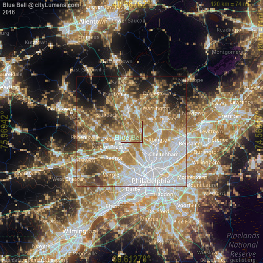
Analysis of Blue Bell night lights 2016
Square area 10x10 km:
 9.9%
9.9%90-99
11.53%80-89
10.23%70-79
17.21%60-69
41.23%50-59
8.6%40-49
1.3%30-39
0%20-29
0%10-19
0%0-9
0%Square area 50x50 km:
18.12%90-99
12.33%80-89
8.69%70-79
10.43%60-69
13.51%50-59
9.79%40-49
6.39%30-39
5.46%20-29
4.15%10-19
5.44%0-9
5.68%Clear (daylight) street map image can be seen on geolist.org.
Map coordinates:
40° 41' 15.4" North, 75° 58' 9.9" West
40° 9' 8.4" North, 75° 15' 58.6" West
39° 36' 46" North, 74° 33' 47.4" West
Some cities around Blue Bell sort by population:
• Norristown
7.1 km =4.4 mi,  241°
241°
• Conshohocken
8.7 km =5.4 mi,  200°
200°
• Maple Glen
7.9 km =4.9 mi,  67°
67°
• Ambler
3.8 km =2.4 mi,  86°
86°
• Plymouth Meeting
5.6 km =3.5 mi,  187°
187°
• Oreland
8.4 km =5.2 mi,  116°
116°
• Dresher
8.5 km =5.3 mi,  98°
98°
• Fort Washington
5 km =3.1 mi, 103°
5180961 (p: 6,067)
Sources (retrieved 2019-11-25):
» Earth at Night: Flat Maps 2012, 2016